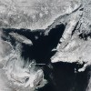
Sea ice in the Gulf of St. Lawrence

The Gulf of St. Lawrence, the outlet of the Great Lakes into the Atlantic Ocean, is building toward its annual peak accumulation of sea ice, according to a recent photograph captured from NASA’s Aqua satellite. According to NASA, each year, the amount of frozen seawater, known as sea ice, in the Arctic Ocean builds from September through February or March as surface air temperatures drop below freezing. As it reaches the peak of its expansion, it begins to form in the Gulf of St. Lawrence.

When in Drought: Satellites show low Great Lakes groundwater

The drought plaguing the country continues to sap the groundwater and soil water of the Great Lakes region, according to new NASA satellite data. The two maps, constructed using data from NASA’s Gravity Recovery and Climate Experiment satellites, show low near-surface and subterranean water levels across the region between January 8 and 14, 2013. These satellites have been used to examine surface soil and ground water levels since they were launched in 2002. While not as low as some areas of the southeast or west, much of the region remains below the 1948-2009 average. Average levels are denoted by white space on the maps, while above-average is blue and below-average appears red.

Satellites reveal scant Great Lakes ice cover


A composite map of the Great Lakes produced by NOAA’s CoastWatch organization shows near-historic low ice coverage across the region. The map, known as the Great Lakes Surface Environmental Analysis, is a composite of data taken from NOAA satellites orbiting the earth’s poles and radar scans of the lakes by the National Ice Center. The resulting image shows surface water temperature and ice coverage, important data for region scientists, fishermen and boaters. The map’s data is updated daily. “Previously, the lowest ice coverage year was 2002,” CoastWatch manager George Leshkevich said.

Lake Ontario glints at spacecam

Sun glints off the surface of Lake Ontario in the lower right corner of this image taken recently by astronauts on board the International Space Station. The mirror-like effect is known appropriately as sunglint. NASA’s Earth Observatory reports the picture was taken when the station was over southeast Nova Scotia and about 740 miles from the centerpoint of the image. From this perspective you can see Lake Huron’s Saginaw and Georgian bays above and to the right of Lake Ontario, and the Finger Lakes of New York to its left. Sunglint also highlights Lake Erie to the west, but the angle makes it appear duller than Lake Ontario.

NASA satellite shows Great Lakes region hit hard by drought

NASA’s Earth Observatory has a remarkable view of the impact of the summer drought. Parts of the Great Lakes region are among those hardest hit. The image depicts plant health in the central U.S. with data collected by the space agency’s Terra satellite. Brown areas show where plants have taken a hit, cream indicates normal growth  and green indicates lush vegetation.  Gray indicates where data could not be collected because of snow or cloud cover. Things look particularly bad in southern Wisconsin, Michigan, Indiana and Illinois.

Here’s a chance to check out your neighborhood from space

Here at Echo we have a special fondness for satellite imagery. Sometimes outer space offers the best vantage point from which to get a sense of Great Lakes issues. Check out this view of the ice break up on Lake Erie and the subsequent agricultural runoff bringing the nutrients that feed the lakes algae headaches later in the summer. Want more? NASA and the U.S. Geological Survey are customizing local landscape images for six U.S. citizens who enter the “My American Landscape” contest.  Just send them an e-mail describing the landscape changes near you and what you hope to learn about them.