Mild winter, early runoff spur swirling sediment in Lake Erie

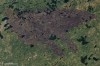
A mild winter left Lake Erie nearly ice-free. On the first day of spring last week, a NASA satellite snapped a picture of the southern Great Lakes region and showed sediment clouding up the shallow lake. The colors in the image are accurate. The tan colored-water swirling around the shoreline is sediment rushing in from streams and rivers. The warm winter brought more rainfall than snow, so there was increased runoff.

Satellite Watch: Fly through the Great Lakes aurora

This time-lapse video by NASA’s Earth Observatory was made from a series of photographs to make a cool flight simulation over the Great Lakes. See if you can spot the big cities, aurora borealis and lightning bolts (and if you get stuck, look here at a labeled NASA photograph).

NASA image of Boundary Waters blaze

This image was sent to me by a particularly imaginative and dorky friend, who said she saw a “seal looking up.”

Actually, it is an Oct. 10 NASA Earth Observatory satellite image of the remains of a massive wildfire that raged across northern Minnesota for nearly two months. The burned areas show as the charcoal outline. Lightning ignited the blaze in the Boundary Waters Canoe Area Wilderness on Aug. 18.  The fire is now 80 percent contained, according to the Duluth News Tribune.

NASA shows Siberian lake painted with fog

NASA recently posted a satellite image of the world’s greatest lake painted with fog. The fog’s perfect outline of Lake Baikal in Siberia is a phenomenon known as evaporation fog. It happens when surface water evaporates into cold air and forms a cloud. Lake Baikal isn’t the only great lake with fog events. The North American Great Lakes often experience lake effect, when warm, moist air blows off the lake and mixes with the cooler air over land to create fog and stratocumulus clouds.

Watch a cyclone develop over the Great Lakes

A NASA satellite caught a huge cyclone storm last week swirling over Lake Michigan and surrounding states. A cyclone is an area of low pressure where winds flow counterclockwise in the Northern Hemisphere and clockwise in the Southern Hemisphere, according to the University of Illinois cyclone webpage.  They usually develop when a warm front from the south meets a cold front from the north.  The cold and warm air wrap around a center of low pressure and the air in the center where they meet causes clouds and precipitation. Mid-latitude cyclones cause stormy weather in the continental U.S.  While their comma shape usually identifies them, I distinctly see a shrimp in the above NASA photo. Watch the shrimp, or comma, develop in a very cool animation from the Geostationary Operational Environmental Satellites that shows the storm’s progress from September 25 to September 27.

Satellite images detect air pollution in the Great Lakes region

Satellite images recently showed air pollution from Ontario fires in the Great Lakes region. Nitrogen dioxide, which forms when nitrogen combines with oxygen during combustion, appears in NASA satellite images taken from July 15 to July 18. The fires caused thousands of Canadian residents to evacuate. The image was created with NASA’s Ozone Measuring Instrument. It measures the number of nitrogen dioxide molecules in a cubic centimeter.

Satellite watch: Lake Michigan’s tendril plume

On Dec. 17, a NASA satellite sailed over southern Lake Michigan after winds whipped up a tendril-like sediment plume. The satellite captured an image of the plume that caught the eye of the people behind the NASA Earth Observatory, an online repository of satellite images, photographs and other illustrations of both natural phenomena and human impacts on the planet. The plume results from winds blowing in from the north that set the water in southern Lake Michigan circulating in a counter-clockwise pattern called a gyre. The movement stirs up sediment from the lakebed, according to the Observatory.

Satellite watch: A rare cloudless day over all five Great Lakes

NOAA’s Great Lakes CoastWatch website is updated daily with satellite images of the lakes. It’s a great site, but unfortunately the images are often simple pictures of the tops of clouds floating over the region. But, as a post on NASA’s Earth Observatory site points out, the sky opened up in late August and gave the agency’s Aqua satellite caught a clear, cloudless glimpse of the Great Lakes region. Click the image above for an absurdly large version of the file.