Echo
Lake Michigan “doughnut” bloom update: See it from space
|
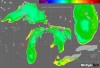
The Lake Michigan “doughnut” – a huge ring-shaped bloom of phytoplankton that circles the late-winter waters of the Lake’s southern basin – is disappearing.
Great Lakes Echo (http://greatlakesecho.org/tag/satellites/page/5/)
Satellites provide an usual view of the Great Lakes environment.
The Lake Michigan “doughnut” – a huge ring-shaped bloom of phytoplankton that circles the late-winter waters of the Lake’s southern basin – is disappearing.

A decade-old discovery in Lake Michigan is already disappearing.
A month of satellite images of Lake Erie shows a dramatic transformation.
Check out this series of images that starts with an ice-covered lake that quickly cracks apart.
As the days progress you can see the annual spring mixing of fine-grained mud that is stirred from the lake bottom and suspended in the water column.
Worry wanes over the chance of flooding brought on by the melting ice bridge at the southern tip of Lake Huron. But a few freighters heading through the St. Clair River have gotten stuck in ice chunks that are gathered up like “sand bunched in an hourglass,” Tammy Stables Battaglia writes in the Detroit Free Press. The hourglass metaphor is apt. You can see it in action here:
The Cooperative Institute for Meteorological Satellite Studies — a joint effort between UW-Madison, NOAA and NASA — runs a blog featuring posts of weather-related satellite imagery. The posts often include beefy animated images of things like volcanoes in the West Indies and potential vorticity anomalies on the California coast. Luckily, the institute’s Wisconsin bias sometimes shows through and they offer up cool Great Lakes scenes. In December, they put together this mesmerizing shot of cloud bands streaming over Lake Superior. Photo: University of Wisconsin-Madison Space Science and Engineering Center
Be sure to let the whole image load and start looping, which could take a few minutes.
By Jeff Gillies
jeffgillies@gmail.com
Great Lakes Echo
Sept. 17, 2009
The Great Lakes and the Chesapeake Bay both field noxious summer algae blooms fueled by dirt and nutrients from farm fields. The six northeastern states that drain into the Chesapeake Bay have a patchwork plan to curb it. It doesn’t work and never will, says a recent report by the Environmental Working Group, a non-profit lobbyist and research group. The report claims runoff prevention programs fail because they’re voluntary — farmers that don’t want to participate don’t have to.
Some Great Lakes watersheds sweating off the winter freeze are sending huge brown plumes of sediment into Lake Erie and Lake St. Clair. But are these smudges, visible in satellite photographs, a sign of spring or a sign that something is wrong? “It’s both,” said the Ohio Department of Natural Resources’ John Matthews on the Lake Erie plume. “It’s normal, but it’s also a function of how we’ve affected stream channels in that watershed.”