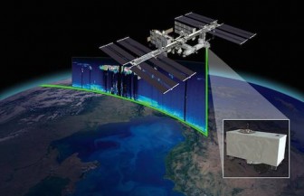
CATS instrument onboard International Space Station will use LiDar to scan planet. Image: NASA Goddard Space Flight Center
NASA is set to launch an instrument aboard the International Space Station that can track air pollution across the Great Lakes and measure how much clouds are contributing to climate change.
It’s called CATS, which stands for Cloud-Aerosol Transport System.
And it has long-term implications for Great Lakes climate predictions.
Sending this remote sensing instrument to the space station will fill the impending data gap currently filled by another satellite that will soon be retired.
CATS will measure clouds and air pollution such as, mineral dust, smoke and other particulates with LiDar, a technology that fires laser beams that scatter off clouds and aerosols.
Once the instrument detects the returning light, scientists can measure atmospheric properties, including the height of clouds and pollutants, said John Yorks, lead scientist at the Goddard Space Flight Center in Greenbelt, Md.
The CATS investigation is a global one, although the fact that it will travel across the Great Lakes means it will give information especially helpful here. Matt McGill, the project’s principal investigator at the Goddard Space Flight Center, said the instrument will benefit regional climate predictions.
“The vertical profile of clouds has an impact on [global] warming,” he said.
CATS logo. Image: NASA Goddard Space Flight Center
“High clouds tend to heat the earth, so you can logically draw inferences to growing seasons and crop yields.”
These high, thin clouds allow the sun’s radiation to pass through the atmosphere while also trapping some of the outgoing radiation, which warms the surface of the planet, McGill said.
The Great Lakes region tends not to have many harmful particles in the air, said McGill, although sometimes wildfires transport smoke and other pollutants over the lakes from the Pacific Northwest and northern Canada.
CATS data is most relevant to the Great Lakes when talking about clouds, rather than aerosols, especially in terms of long-term assessments of climate change.
“The challenge of using active remote-sensor systems in smaller regions like the Great Lakes is sampling,” said Bob Holz, research scientist at the University of Wisconsin-Madison’s Cooperative Institute for Meteorological Satellite Studies.
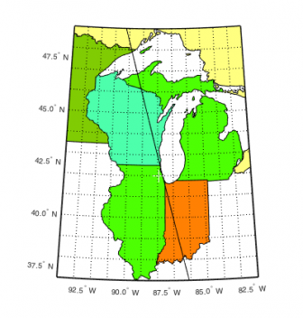
CATS will follow an unfixed orbit over part of the Great Lakes. Image: Space Science Center, UW-Madison
“Unlike an imager, which actually scans, these satellites look straight down. So the satellite might only pass over part of the Great Lakes, basically drawing a line over Lake Michigan or Lake Erie,” he said.
But that doesn’t rule out long-term predictions for the region.
Holz recently completed a Great Lakes project using CALIPSO, an active instrument similar to CATS. That acronym stands for Cloud-Aerosol LiDar and Infrared Pathfinder Satellite Observation.
The project measured pollution in the lowest part of the Earth’s atmosphere. But the satellite’s orbit didn’t provide enough information to make any region-specific predictions.
“It did demonstrate the concept and will be a useful product globally,” he said.
All climate predictions involve clouds and CALIPSO and CATS best measure their properties, Holz said. CALIPSO follows a typical NASA free-flying orbit crossing the equator. It was launched in 2006 but will soon be out of commission. CATS presented an opportunity to fly a similar instrument on the International Space Station.
But CATS follows a different orbit. Unlike CALIPSO, its orbit is not fixed, said McGill. This means CATS won’t always pass over the same location at the same time. The difference will allow CATS to see the day to night changes in cloud and aerosol features.
The atmosphere changes a lot from day to night.
“During the day, solar heating and mixing occurs — pollutants are pumped into the atmosphere and the height of the planetary boundary level rises,” McGill said. “At night this collapses because solar heating and mixing goes away, along with a lot of the pollution sources like factories and cars.”
Where and how these pollutants transport is of interest, he said. Day to night, or diurnal changes are important to study for any area because not much is known.
CATS demonstrates this new technology for Earth science. It is not a replacement for CALIPSO, but it will continue collecting similar data later this year, said Yorks. And whether tracing pollution transport over the Great Lakes or amassing vertical cloud data, CATS will provide information critical for developing future global climate models.