
Surber’s map measures 5 by 2 feet. It documents 50 springs flowing into Lake Superior. Image: Minnesota DNR
By Carin Tunney
A 1920s-era map is providing new inspiration to track more than 10,000 springs in Minnesota, according to the state Department of Natural Resources.
The yellow-linen relic stretches five feet and documents 50 miles of the remote areas along the state’s northern shore, said DNR research analyst Greg Brick. He recently uncovered the long-forgotten map within the DNR files.
The map of wetlands was drawn by Thaddeus Surber, an aquatic biologist who did much of his research on foot, Brick said. It offers new opportunities to expand research on area freshwater resources such as groundwater springs.
The DNR estimates there are 22,000 springs statewide, officials said. But most springs in northern Minnesota are poorly documented. The map spurred interest in a project to create an official inventory. That project received funding through a state grant this year.
“Finding this map tucked away in the files is very exciting,” Brick said. “He (Surber) maps streams that are way back in the backcountry. I’ve only visited several of these locations and they are kinda hard to find.”
But there are clues within the landscape. Springs can be found near other water since they sometimes flow into streams or creeks, Brick said. Soils like gravel, shale, sandstone or limestone can push water from the earth creating a natural spring.
Brick points to a small spring seeping from a crack in a ridge. Image: Greg Brick
“We’re kind of spoiled now. We just go online– boom. There’s a USGS quadrant with the elevations and the contours,” Brick said.
Another challenge — Surber’s map came before topographic maps and GPS, which make it easier to navigate over hills and valleys and track down exact coordinates.
The DNR is also using an aerial technique called Light Detection and Ranging to filter out vegetation, Brick said. Also known as LiDAR, the technique uses lasers to find ridges or valleys where merging soil types might be.
Ultimately the only way to study springs is by visiting them on foot.
“Finding these locations is difficult, but the few I have found they’ve far surpassed these little wet outcrops that we’ve found on (highway) 61 as you’re speeding toward the casino,” Brick said.
The DNR has created a smartphone app and online form for citizens to report GPS locations of springs. The project was launched in February. About 100 people have used the app or online form.

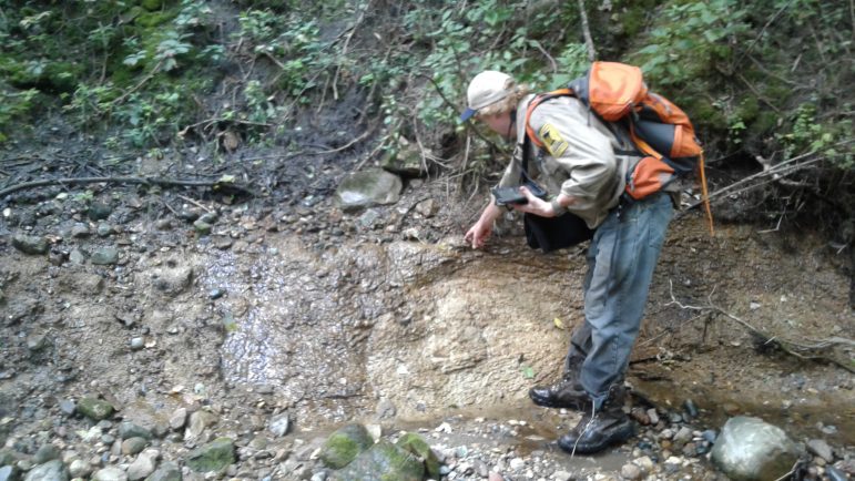
Brick conducts measurements at the Canfield Spring in southeast Minnesota’s Wabasha County. Image: Greg Brick
Tom Holtzleiter is among these citizen scientists and has been chasing water since he discovered a spring inside a cave as a kid. Thirty years later, he still treks the woods searching for water naturally flowing from the earth. So far he’s found dozens, he said.
“It’s unique that water just bubbles out of the ground,” Holtzleiter said.
Holtzleiter said the springs often smell like watercress and potting soil because the earth around them is damp. He finds them on hillsides or near creeks.
But often it’s as easy as getting his feet wet.
“If you are out walking around that’s when you can step in them,” he said. “The whole area around the spring can be a saturated muddy mess.”
The DNR will confirm the location of Holtzleiter’s springs and others reported by citizens. They also measure acidity levels, temperatures, flow rates and collect information about the surrounding plants. According to the DNR, previous measurements on known springs are not reliable because of outdated methods using decades-old tools. But if those measurements are accurate, they already indicate decreasing flows. The drop could be attributed to agricultural practices, deforestation, industry and climate shifts, Brick said. The work creates more scientific measurements to study.
The DNR says locating springs is critical environmental research on the ecosystem, including fish, like brook trout, sculpin and other aquatic species.
Jeff Eibler, with the DNR Division of Fish and Wildlife monitors streams where springs are present. He sets out devices known as loggers to measure water temperatures of springs throughout the year.
“With concerns about shifts in climate we are even more concerned about cold water resources,” Eibler said. “I’ve seen in several places that the only places we see cold water species like trout are immediately below these cold water springs. Those (cold water springs) are critical resources to begin with, but as time goes on those are going to become even more critical.”
Brook trout can’t tolerate temperatures above 65 degrees, he said. Many streams soar above that temperature in the summer.
Eibler said his monitoring shows streams are able to maintain year-long temperatures of about 45 degrees in areas where springs emerge.
Without cooler temperatures, trout move on, Eibler said.

The DNR survey will include collecting information on vegetation growing near the springs. Image: Greg Brick
“The beauty of these springs is they are very consistent,” he said.
Much of the DNR’s own footwork is focused on public lands near the St.Croix and Minnesota River Valleys, Brick said. Many springs were found in the St. Croix Park near Hinckley.
People have found springs under old military stables, breweries and inside of caves.
Although the inventory is aimed at finding new springs, the DNR also lists locations of known springs on its website.
The $370,000 spring inventory project is funded by the Legislative-Citizen Commission on Minnesota Resources. The project is funded through 2019.
While it’s unlikely the agency can inventory every spring, Brick said the online app is already showing potential.