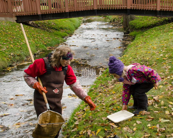
Michigan volunteers collect macroinvertebrates last October. Image: John Lloyd
By QING ZHANG
The Michigan Clean Water Corps (MiCorps) will announce the winners of a new round of grants for volunteer stream monitoring projects by June.
Three grants worth a total of $50,000 are available to survey aquatic macroinvertebrates and to inventory where railroads cross streams.
“This year we received 10 applications for the stream grants. I expect about five or six of them will be funded,” said Paul Steen, the program manager for the network of volunteer monitoring projects.
Such volunteer monitoring is common across the Great Lakes region, including such groups as the Wisconsin Water Action Volunteers, the Pennsylvania Alliance for Aquatic Resources Monitoring, the Minnesota Citizen Stream Monitoring Program, the Ohio Stream Quality Monitoring Program, the Indiana Hoosier Riverwatch as well as the Illinois RiverWatch.
The Michigan Volunteer Stream Monitoring Program of MiCorps has received a similar amount to distribute from the Michigan Department of Environmental Quality for 11 years. The fund has supported nearly 40 volunteer groups gathering data from more than 800 sites, Steen said.
“We could only go to 50 sites across the state instead of going to 800 sites with the volunteers, so volunteers greatly expand our reach,” he said.
Volunteers mainly monitor aquatic macroinvertebrates, which are creatures like insects and crustaceans and that are visible to the eye.
It’s “pretty cheap and fast” to use macroinvertebrates as samples because they live in the water their entire life, exposed to all the chemicals and the water flow, Steen said. And their lives are controlled by the habitat. So the number and types of these water creatures can tell a lot about a river.
“If you have a lot of macroinvertebrates living in the water, that means it has clean water, has steady flow, has good habitat,” Steen said. “And as a bonus, they are actually very easy to sample.”
In contrast, monitoring chemicals or larger living things like fish and birds requires more expensive and professional equipment, and the process is more complicated for volunteers.
The data can detect immediate problems and long-term water degradation, Steen said.
For instance, volunteers with the Huron River Watershed Council once couldn’t find any insects in the Letts Creek (a tributary to Mill Creek), in Chelsea, he said. They investigated and discovered oil on the creek bed.
They followed it upstream to an auto repair shop with buckets of oily auto parts leaking into the river. The owner hadn’t realized the problem at all.
“People are just unaware of what their actions do,” Steen said.
Another way to use the information is to look at transitions over time, such as at a creek he has studied near South Lyon, he said.
“Over the last 10 years or so the insect population has gone down slowly but surely,” Steen said. “In this case, there isn’t one big emergency that happened to the river, but rather continuous impacts over time.”
That pollution was from a variety of sources such as run-off from yards and driveways instead of a single source.
A good way to solve such non-point pollution is by education of the residents, Steen said, “There is not one particular thing we could do to make our pollution go away, but we can tell people how their everyday actions are affecting this creek.”
Data collected by volunteers is accessible on a website for public use and analysis, said Jo Latimore, a MiCorps program consultant from the Michigan State University Department of Fisheries and Wildlife.
Besides the volunteer themselves, “we also get a lot interest from agencies like the state Department of Natural Resources, local organizations and also students and researchers at colleges,” she said. State officials submit an annual report with the volunteer monitoring data for the Environmental Protection Agency (EPA) about the health of Michigan streams.
The Wisconsin Volunteer Stream Monitoring Program is part of Water Action Volunteers, which is coordinated through the Wisconsin Department of Natural Resources (WDNR) and the University of Wisconsin — Cooperative Extension.
Most of its monitoring projects are supported by grants from local foundations and federal funds. That includes the Wisconsin Environmental Education Board,the North Central Region Water Network and U.S. Department of Agriculture, said program coordinator Kris Stepenuck.
Unlike Michigan’s program that receives $50,000 every year, Stepenuck said her program’s support fluctuates with the grants that are available.
From 2003 to 2006, the program received a national grant and a specific grant for river monitoring. They enabled her to train people and buy equipment for bacteria monitoring. “So at that time, we got a lot of bacteria monitoring,” said Stepenuck.
But now the program doesn’t have money to do that.
So far, the program has received $2,000 for 2015 and has a $1,500-$2,000 operating budget from the EPA to run training activities and buy equipment.
As the biggest volunteer monitoring program in Wisconsin, it coordinates 50 local groups with 450 volunteers. Since it started in 1996, the program has monitored 651 sites across the state.
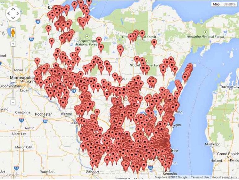
Volunteer monitoring sites in Wisconsin. Image: Water Action Volunteers.
Some local groups represent nonprofit organizations, counties and schools, while others are purely volunteers.
“We rely on many people’s willingness to give without giving them a lot. We don’t give them financial support. We only give them technical support and the database and training,” said Stepenuck.
Volunteers monitor macroinvertebrates, temperature, dissolved oxygen, stream flow and transparency.They collect their data in an online database.
The program this year is searching for three invasive species: the rusty crayfish, Asian clam and New Zealand mud snail. Stepenuck plans to build a map of where they are found.