Editor’s note: This is the second in a series of stories on how new technology is giving researchers a glimpse of the critical nearshore area of the Great Lakes
One of the Environmental Protection Agency’s newest members uses side-scan sonar to look at the watery depths of Lake Michigan.
Fanning its sound waves down to the lake floor, it searches for the returning signals bouncing off the bottom in search of bounty–it found a shipwreck last year.
But the Triaxus Towed Undulator does more than treasure hunts. Beneath the water, it glides behind the Lake Guardian, the agency’s research vessel. With its quick data collection, the agency can do in days what would otherwise take a year, said Glenn Warren, team leader for the agency’s environmental monitoring and indicators group in the Great Lakes National Program Office.
Nearshore Navigators
The Triaxus studies the water and the lake bottom. Its sensors calculate oxygen amounts, test water quality, count plankton, measure chlorophyll and analyze nitrate while viewing the bottom with sonar.
The agency purchased the Triaxus in May 2008. It used it to examine parts of Lake Ontario that same year. The agency began study of Lake Michigan last fall.
“Next … we’ll do Lake Michigan and at least the U.S. half of Lake Superior,” Warren said. The goal is to provide a general view of nearshore patterns, he said.
“Once we get that information we can perhaps develop indicators based on the different sensory information,” he said. “Then we can start comparing that year to year.”

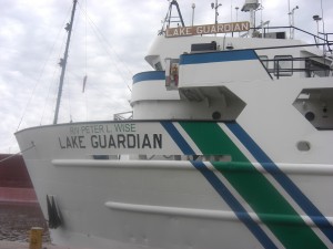
Researchers with the EPA use the Lake Guardian to tow the Triaxus through Great Lakes waters. Photo by Kimberly Hirai.
For example, Warren said, if they knew the area where a river entered the lake, they could determine chlorophyll and zooplankton levels at that point within the nearshore area. Those measurements could be compared with past years to see how the river affected the nearshore.
The data gaps are real, as is the need to fill them.
“The difficulties are that it’s a variable environment, so you can go along the shore and get very different chemical and biological readings for measurements and that has led to people not sampling it very frequently or very well,” he said.
Yesterday: Exploring below the Great Lakes’ surface
Tomorrow: Stealth II hovers with cameras over lake bottom
Pingback: Robot week: Remote-controlled Stealth II reveals nearshore landscape | Great Lakes Echo
Pingback: Nearshore navigators | Great Lakes Echo