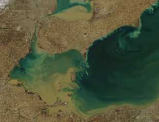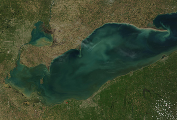
Spring rain and melting snow send soil from farms into streams, rivers and ultimately the Great Lakes. Click to enlarge. Image: NOAA CoastWatch
Some Great Lakes watersheds sweating off the winter freeze are sending huge brown plumes of sediment into Lake Erie and Lake St. Clair.
But are these smudges, visible in satellite photographs, a sign of spring or a sign that something is wrong?
“It’s both,” said the Ohio Department of Natural Resources’ John Matthews on the Lake Erie plume. “It’s normal, but it’s also a function of how we’ve affected stream channels in that watershed.”
Lake St. Clair’s plume got a recent boost from the worst flooding in southern Ontario in 20 years, said Brian McDougall, director of watershed services at the St. Clair Region Conservation Authority in Ontario.
Matthews said the Maumee River, which runs through 130 miles of Indiana and Ohio farmland, is one of Lake Erie’s major sources of sediment. Northwestern Ohio’s flat wetlands didn’t offer much drainage in the 1900s, he said, so farmers who wanted to get water moving dug channels to rivers and streams running to Lake Erie.
“Those systems are just a little more efficient at carrying both water and sediment,” he said. “Wherever there’s sediment moving with water there’s typically a certain amount of phosphorus that moves with it.”
That phosphorus comes from the region’s farms where it’s applied as a fertilizer. Once the phosphorus makes it to Lake Erie, it fuels algae blooms that produce toxins and wash up on Michigan and Ohio beaches in rotting mats.
More water flows from the Maumee into Lake Erie in March and April than other months, said Ohio DNR water specialist Dave Cashell.
Matthews said the Ohio DNR has worked with landowners on digging ditches with gently sloping banks. The flatter banks allow sediment to settle and wetland plants to grow.
“The more we learn about streams, the more you realize how complex that system is,” he said. “We’ve just thought about it as kind of a conveyance pipe, and that’s what people are starting to rethink a little bit.”
Ontario’s Sydenham and Thames rivers are the big sediment sources for Lake St. Clair, McDougall said. The conservation authority helps landowners build tree-lined buffers along riverbanks to keep the intensely agricultural region’s fertile topsoil in place. But rain and melting snow in December and February triggered the region’s worst floods in 20 years.

Blue-green blotches show Lake Erie’s summer algae blooms. Photo: NASA MODIS
That was more than the buffers could handle, he said.
McDougall said February floods can add to sediment plumes in April.
“As the water drops it coasts everything with that sediment,” he said. “Even the grasses that are on the banks of the river that were coated with that sediment are now going to be washed clean as the water level rises and falls.”
But snowmelt runoff isn’t always bad news. Tom Meronek, fish biologist with the Wisconsin Department of Natural Resources, said a February warm-up brought fresh water to a lake in the midst of a fish die-off.
Meronek said fertilizer-fueled algae blooms turn the Big Eau Pleine Reservoir green in summer. The algae decays in winter and sucks up the dissolved oxygen fish breathe. Meanwhile, the ice prevents surface air from recharging the oxygen supply and fish go belly-up.
Meronek said fish caught a break when a February thaw sent a shot of high-oxygen water into the lake, which sits behind a dam on the Big Eau Pleine River.
“It tended to bring the oxygen up for a few weeks,” Meronek said. “During that time it gave our fish a chance to move from the aeration system in the middle of the flowage back upriver to where there was better oxygen.”
But after those few weeks, oxygen levels dropped and the fish kill was back on, he said.
Meronek said the fish kill isn’t as bad as it could have been: 90 percent of the dead fish are carp.
“It’s not a fish that we care whether they live or not,” he said. “If they die, we’re not restocking them. That’s for sure.”
Pingback: Great Lakes Echo» Blog Archive » For Great Lakes mudpuppies in decline, new Canadian research is a bright spot
Good use of satellite imagery here. I blogged about how such images can drive the creation of news stories. See: http://bit.ly/12ANmj