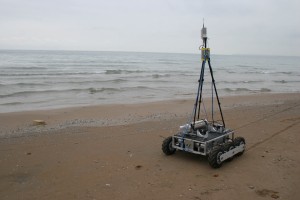
This rover collects data in areas too shallow for boats and too dangerous for people. Photo: Tom Cons
Editor’s note: This is the fifth in a series of stories on how new technology is giving researchers a glimpse of the critical nearshore area of the Great Lakes
When the water is too shallow for a boat and too dangerous for a person, it’s time to send in a robot researcher.
At least, that’s what Tom Consi hopes will be the mindset when he launches the remote operated vehicle he’s worked on for the past year.
“People need fundamental data in the surf zone, and our robot’s designed to go out and get it,” he said.
Consi is an associate scientist at the Great Lakes Water Institute in Milwaukee
He and a small team of engineering students from the University of Wisconsin-Milwaukee spent the past year developing a robot that can drive underwater and collect data about the nearshore ecosystem.
Nicknamed “LMAR” for Lake Michigan Amphibious Robot, the robot stands about one foot tall and is about the three feet square.

Nearshore Navigators
The battery-powered robot follows commands from an onshore laptop. A radio antennae sticking up out of the water like a miniature mast transmits instructions to the onboard computer.
When it’s ready to go, the robot drives straight into the water like a six-wheeled all-terrain vehicle.
LMAR can only go about six feet below the surface before losing radio contact, but that’s deep enough to get into trouble.
“It’s a violent area,” Consi said. “So that makes it a challenging area to design a machine that can survive against the crashing waves.”
The shifting sand adds another complication, he said. Many of the test runs last summer ended with his students dragging the robot out of the water.
“Basically you have it run in the water, watch it break, figure out what broke and then fix it or change the design,” Consi said.
That design evolution led to a robot with an increasingly reliable platform — a necessary first step to create an instrument that can withstand nearshore conditions and collect data.
While there are other remotely operated vehicles exploring the Great Lakes — NOAA and the USGS each have one, as do a few other laboratories in the region — Consi’s will be unique in its ability to drive along the nearshore bottom and collect measurements and samples for an extended duration.
“My vehicle is more of a turtle. It can carry a lot more power and a lot more (instruments and samples). So it can go out and take lots of measurements,” he said.
When it is complete, probably sometime this spring, the robot will measure water conditions and collect samples for laboratory analysis. Most of Consi’s sampling goals for LMAR are basic: temperature, pH, conductivity. But access to that data will be a big step for many scientists.
“In the underwater world, access is so limited. If you can reliably get simple information … reliably at any time of the year, that’s good stuff,” he said.
Consi hopes his robot will fill critical knowledge gaps about the Great Lakes nearshore.
“It’s an incubator region for the ecosystem and it’s also just a portal for pollution into the lake, so it’s a key choke point,” he said. “And also because it’s so turbulent, it’s more of a challenge to understand and to model. There are no models that exist yet for circulation in the very, very nearshore…That’s a research area that my robots are trying to support.”
Ultimately, Consi knows he will have to demonstrate the usefulness of his robot before it catches on in the scientific community, but he isn’t too worried.
“Who doesn’t like robots?”
Yesterday: Lure of nearshore data prompts a Great Lakes buoy arms race