By Josh Bender
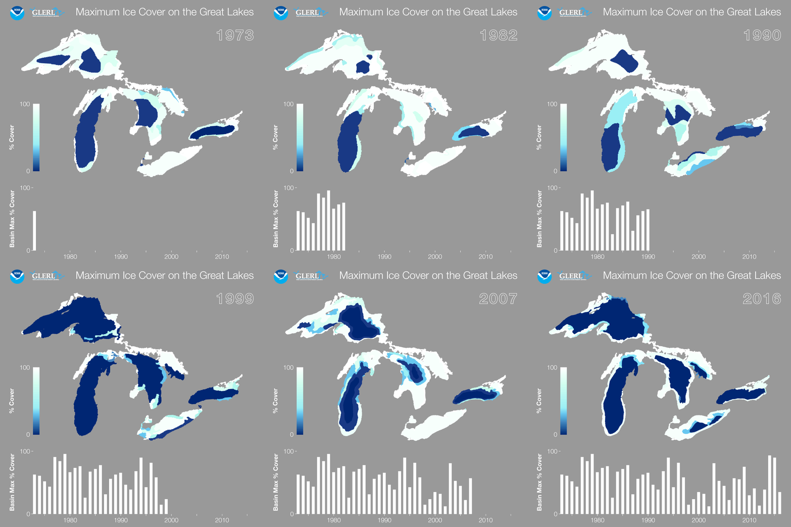
A new animation from the National Oceanic and Atmospheric Administration’s Great Lakes Environmental Research Laboratory demonstrates the record highs and lows in peak ice coverage of the Great Lakes since 1998.
That year ice covered 11.5 percent of the lakes at its peak.
Since then, the laboratory recorded its lowest ever peak coverage, 9.5 percent in 2003, and it’s second highest, 92.5 percent in 2014.
There is no apparent, commonly accepted reason for the fluctuation, some Great Lakes climate experts say.
The record lows could be due to climate change, said George Leshkevich, an expert on Great Lakes ice cover at the laboratory.
With less ice to reflect sunlight, the lakes absorb more heat from the sun, he said. This warming feeds into itself — less ice leads to more heat absorbed by the lakes which leads to even less ice.
With warmer water temperatures going into each winter, air temperatures must be even colder to cause the lakes to freeze, he said.
In the fall of 2013, air temperatures were especially cold and ice began forming on Lake Superior by late November, he said.
There may be no singular unifying cause of the changes in all the lakes’ ice coverage, said Jeff Andresen, Michigan’s state climatologist and a geography professor specializing in applied climatology at Michigan State University.
“There is quite a bit of research that says the behaviors in each of the lakes might be different because of their different geographical features,” he said.
The changes may also be due in part to the El Nino-Southern Oscillation, a periodic changing of wind and sea surface temperatures along the eastern Pacific, said Jia Wang, an ice climatologist at the Great Lakes Environmental Research Laboratory.
As the jet stream travels, it’s temperature is either raised or lowered, depending on if the El-Nino Southern Oscillation is in its warm, cold or neutral phase, Andresen said.
This air eventually reaches the Great Lakes region, he said. “If you mess with the jet stream you mess with our weather.”
This past winter was warmer than average and currently the El Nino Southern Oscillation is in its warm stage, he said. “That is not a coincidence.”
The warming Arctic may also slow the jet stream, causing less seasonal change in air temperature, said Steve Vavrus, a climatologist at the University of Wisconsin’s Nelson Institute Center for Climatic Research.
Winters are more likely to stay uniformly bitter cold or mild and warm throughout as the air passing through the Great Lakes is more uniform in temperature, he said.
Scientists at his center are trying to determine if the warming of the Arctic causes the jet stream to create more extreme weather, he said.