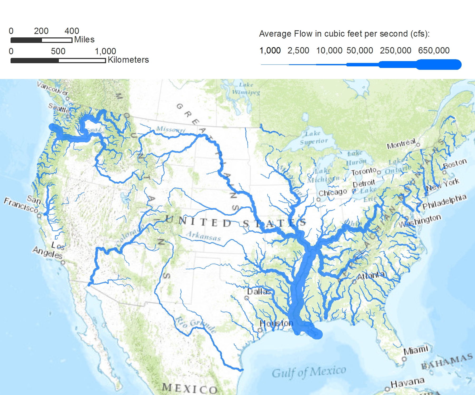
I came across this map on Peter Gleick’s Significant Figures blog.
In most maps major highways are wider than minor ones and large cities get large dots.
This map gives U.S. rivers similar treatment, with the width of the rivers proportional to the square root of the estimated average annual flow of the river. If you can’t get your mind around that math, just know that the fatter they are, the more water they carry.
As cool as this is, the map is not without problems. The St. Lawrence River which drains the Great Lakes — nearly 20 percent of the world’s fresh surface water – looks like no great shakes. Neither do the St. Clair or Detroit rivers which drain lakes Huron, Michigan and Superior into the lower part of the basin.
And there’s nothing going on in Canada.
Gleick readily acknowledges this, noting that the data set he’s working with is of the 48 continguous U.S. states.
In the comments section of his blog, he explains: “If and when we get the data for Mexico and Canada, we can redo North America properly and show the great rivers of Canada and the proper flows of the rivers we share!”
I hope that happens.
Meanwhile, this is an excellent illustration of the need for environmental news communities to be built not around political jurisdictions, but around natural features that they share. A founding principal of Echo is that we strive to report news and information in the context of the Great Lakes watershed. To properly serve our community we need water data from Canada as well.
And not just for Canadian readers.
Our environmental news community is not a collection of political jurisdictions. Rather it is an irregular piece of geography that includes parts of eight states, parts of two provinces and parts of two nations.
The independent actions of political jurisdictions sharing a natural resource affect each other. They don’t happen in a vacuum. Watershed reporting can help bring understanding of those independent actions on the shared natural resource.
This map also got me thinking about the concept of some lakes simply existing as the widening of rivers. After all, aren’t Lake Superior and Lake Michigan simply the upper reaches of that St. Lawrence River system?
Hydrologists say that technically Lake Michigan and Lake Huron aren’t two lakes at all, but rather one lake with a significant narrowing at the Mackinac Bridge.
Gleick says he’d like to see a map that portrays the Amazon River in this manner. It carries 10 times the flow of the fat Mississippi in this map.
Me? I want to see what it looks like if you consider the Great Lakes as merely fat rivers.
