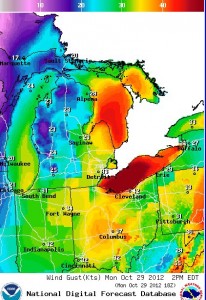
Great Lakes wind conditions 2 p.m. Monday. Image: National Oceanic Atmospheric Administration
While Great Lakes freighter captains braced for high winds spun off the East coast hurricane Monday, Midwest surfers anxiously anticipated the high waves it created hundreds of miles from the storm’s center.
“The surfing community here is getting really excited,” said Mitch McNeil, vice president of the Chicago Chapter of the Surfrider Foundation. About 40 people were set to surf Lake Michigan Monday afternoon near Chicago.
The 12-foot high waves are expected to be more than twice as high Tuesday.
“It is kind of an eye opener for surfers,” McNeil said.
Michigan receives rain from hurricane remnants every three to four years. But Hurricane Sandy’s impact on Midwest weather is unusual, experts said.
“It’s unprecedented in the past 58 years for a northeast U.S. hurricane to impact Great Lakes weather this strongly,” Jeff Masters, director of meteorology for

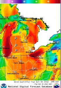
Great Lakes wind conditions projected for 2 p.m. Tuesday. Image: National Oceanic Atmospheric Administration
Weather Underground Inc., wrote in an email. “The last storm that did so was Hurricane Hazel of 1954, which killed 81 people near Toronto and brought storm-force winds to the Great Lakes.”
Great Lakes freighter captains began taking precautions Monday morning, said Glen Nekvasil, vice president of corporate communications for the Lake Carriers Association.
“Many of our members will anchor their boats and ride out the storm,” he said.
“For those who have already unloaded they are deciding to dock their boat.”
Others may choose to unload later, but ships won’t leave port until the storm passes.
“There are about half a dozen ships right now anchoring in the St. Mary’s River that do not want to go through Lake Huron,” Roger LeLievre, vice president of Great Lakes and Seaway Shipping Online, said Monday.
Meanwhile, winds off of Lake Erie have already damaged signs.
The weather over the Great Lakes is actually a convergence of three systems: Hurricane Sandy, a winter storm and an arctic front. The region will be most affected by the winter storm coming from the west.
Good explanation of storm convergence by Associated Press science writer Seth Borenstein:
Though the storm will weaken as it travels over land, winds will pick back up as it hits Pennsylvania and lower Michigan, said Brandon Hoving, a forecaster at the National Weather Service Weather Forecast Office in Grand Rapids, Mich.
Winds of up to 40 mph were to hit Monday night with waves hitting 10 to 15 feet high near the Great Lakes coasts, he said. Winds will hit 45 to 50 mph Tuesday and produce 12- to 18-foot waves.
The strongest hit area will be from Holland, Mich., to as far as Chicago, Hoving said.
“It’s a good idea to get off the lakes.”
Not everyone agrees.
McNeil said surfers need to be careful of the wind, but that it is nothing they worry about.
“Everyone is very much plugged in and everyone is kind of on their own,” he said.
Great Lakes surfers are familiar with strong winds, said Will Beaton, board member of the Surfrider Foundation’s Lake Michigan Chapter. “Fall is our favorite season.”
More than 100 people will surf Lake Michigan this week, Beaton said. The best waves are in Lake Superior. But cold temperatures discourage surfers there.
Well, not all of them.
“I am going surfing tomorrow,” Stenfan Ronchetti said Monday.
While strong winds are frequent on Lake Superior, Sandy will still bring the biggest waves he has ever seen there, said Ronchetti, director of the Surfrider Foundation’s Minnesota-Superior Chapter.
“I am not concerned of the safety,” he said. “Most people have been doing this long enough.”
Check out projected wave heights with the Great Lakes Environmental Research Laboratory forecasting tool.
Dmitri Barvinok, Silu Guo and Maranda Trombley contributed to this report
