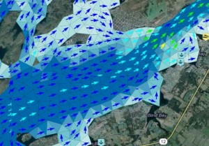
A zoomed-in screen capture of the St. Lawrence River Forecast Map. Click image for access to the tool. Photo: Great Lakes Observing System.
An online tool for charting water currents and depths can help St. Lawrence Seaway boaters plan safe recreational trips.
The tool pools wind and water data from several U.S. and Canadian research agencies and incorporates them into a forecasting model every three hours, said Riley Young Morse program manager at the Gulf of Maine Research Institute and developer of the tool’s user interface.
Boaters can click a point on a computer-generated map of the seaway closest to where they need information. This produces the current water current conditions and forecasts for that area.
The user can set up an alert for that spot to be notified when water depth or current speed goes above or below a certain value, Young Morse said. Such alerts can be sent by e-mail or by text message.
The tool also includes information on marina and boat launch locations, said a press release by the Great Lakes Observing System, a non-profit association of Great Lakes data-sharing agencies that created the tool.
The observing group also plans to extend the Boaters’ Forecast Tool to the entire Great Lakes, said Kelli Paige, program coordinator at the agency.
The expanded program is scheduled to be launched in time for the 2013 boating season.
“In fact, we are looking for recreational boaters to participate in a one hour webinar to preview the Boaters Forecast Tool and offer feedback on what can be done to enhance the tool for a basin-wide application,” she said. The webinars are 6 p.m. Sept. 18 and 2 p.m. Sept. 27. Boaters can register here and here to participate in the discussions.
The observing group developed the tool with the New York Sea Grant and the National Oceanic and Atmospheric Administration’s Great Lakes Environmental Research Laboratory, which are research organizations.
