Echo
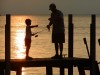
Hunting, fishing boost Michigan economy
|
Despite drought conditions, low water levels and a rash of disease in the white-tailed deer population, fishing and hunting remained a boon to the Michigan economy in 2012.
Great Lakes Echo (https://greatlakesecho.org/tag/echo/page/77/)
Despite drought conditions, low water levels and a rash of disease in the white-tailed deer population, fishing and hunting remained a boon to the Michigan economy in 2012.
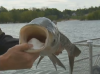
University of Minnesota researchers are recruiting common carp to test a way to eliminate Asian carp, according to WCCO-TV. Fisheries experts fear that the invasive Asian carp may spread into the Great Lakes and elsewhere and outcompete native fish with its voracious appetite. The researchers are fitting common carp, or “Judas fish,” with transmitters to lead them to other, larger schools of common carp, the station reports. “(Carp) seem to be actually exceptionally social, they really hang out together,” researcher Peter Sorensen told the station. “We have to confirm that, but it sure looks that way.”
If the experiment shows how a common carp can “betray” other common carp locations, the same technique could be used in Asian carp populations to help exterminate them in the future, said Bill Hudson, the story’s reporter.
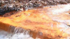
A search for answers about orange water flowing from abandoned coal mines in Ohio’s Stark County.

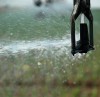
Residents of Great Lakes cities are increasingly victims of urban flooding.
Getting a handle on the problem is difficult as property owners often don’t want to talk about sewage spilling into their homes.

Can pollution be a revenue stream?
Taxing externalities can appeal to both ends of the political spectrum.
And it brings the focus on prevention – the cheapest way to protect the Great Lakes.
Budget constraints and a belief that existing legal solutions to the disputes are sufficient nixed an aquifer protection program, but critics of the decision say the program worked well and is needed.
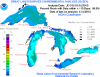
A composite map of the Great Lakes produced by NOAA’s CoastWatch organization shows near-historic low ice coverage across the region. The map, known as the Great Lakes Surface Environmental Analysis, is a composite of data taken from NOAA satellites orbiting the earth’s poles and radar scans of the lakes by the National Ice Center. The resulting image shows surface water temperature and ice coverage, important data for region scientists, fishermen and boaters. The map’s data is updated daily. “Previously, the lowest ice coverage year was 2002,” CoastWatch manager George Leshkevich said.

Detroit Public TV and The Nature Conservancy on Wednesday hosted a seminar on Invasive Species in the Great Lakes for Great Lakes Now. The first panel discussion featuring experts explaining invasive species, how they arrived and their impact is below.
Gov. Rick Snyder cited concerns about the impact of a changing climate and increasing demand for water.
Environmental groups are broadly supportive of the move.