Many students mistakenly believe that the Red Cedar River cutting through Michigan State University’s campus is severely polluted. To fight that perception, university officials recently repealed a 1960s ban on fishing on campus.
The National Park Service and MichiganTrailMaps.com have produced new trail maps of a pair of Lake Michigan islands near Traverse City, Mich. North Manitou Island and South Manitou Island, part of Sleeping Bear Dunes National Lakeshore, have been added to MichiganTrailMaps.com’s Classic Trails of Michigan map series. Each map illustrates trail grades, primitive roads, maintained trails and unmarked modern and historic pathways. They also mark historic sites, ruins, natural features, elevation changes and hiking amenities found throughout the islands. Each map costs $4.95, and are available at the Sleeping Bear Dunes Visitor Centers, MichiganTrailMaps.com, the Manitou Island Transit ferry company and outdoor shops throughout the state.
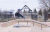
Skateboarders promote sustainability by caring for the structures and surroundings that foster their passion, according to a sociologist at the University of Illinois at Urbana-Champaign. This is shown by general concern for keeping urban environments clean and usable and specific practices like applying wax to upkeep ledges and rails.
Mr. Great Lakes (Jeff Kart) reports from Bay City, Michigan’s Delta College Q-90.1 FM.
This week Kart discusses the 2014 budget for the Great Lakes Restoration Initiative, salmon in Lake Huron and Michigan schools going green. Text at Mr Great Lakes
That’s disconcerting for environmentalists, who call the limit arbitrary and worry it will render the state unable to cope with rising demand for public land.
Each week, Great Lakes Echo features a photo story about a different Area of Concern designated by the U.S. or Canadian governments in the Great Lakes basin. Guess where the area is located, based on the description of the site.
In this photograph from NASA’s Earth Science Photo of the Day, a January thaw caused this ice shelf on the Lake Michigan shoreline to collapse near Winnetka, Ill., according to photographer Neil Libby. As successive winter storms buffet the coast with strong winds and large waves, icy slush builds up on the newly-formed shore ice, creating ice shelves. The ice shelf pictured here stood 8 feet above the water.
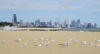
Wildlife researchers cut the population of gulls on Lake Michigan beaches by sterilizing their eggs. The birds tried hatching them instead of laying new ones.