Echo

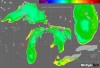
MONDAY MASHUP: Great Lakes tapestry map
|
The U.S. Geological Survey combined maps of geologic features (like rock types) and natural landscape features (like mountains) to make this tapestry map.
Great Lakes Echo (https://greatlakesecho.org/tag/echo/page/169/)
The U.S. Geological Survey combined maps of geologic features (like rock types) and natural landscape features (like mountains) to make this tapestry map.
The Lake Michigan “doughnut” – a huge ring-shaped bloom of phytoplankton that circles the late-winter waters of the Lake’s southern basin – is disappearing.

John Niewoonder was named wildlife biologist of the year by the Midwest Association of Fish and Wildlife Agencies. He’s a Michigan native and key author of the state’s new deer management plan.

This week: Brian Johns of The Youth Farm Stand program at Holmes Foundation Academy in Flint, teaches students to grow vegetables using traditional farming methods, as well as cutting-edge technologies such as hydroponics and aguaponics.
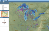
Curious what land is protected in your state?
Then meet CARL – a Conservation And Recreation Lands map.

A decade-old discovery in Lake Michigan is already disappearing.

From 2003 to 2007, researchers estimate that the cormorant ate 13 million fewer yellow perch and 600,000 fewer smallmouth bass in two large Lake Ontario cormorant colonies.

This week: The debate on “shrinking the city” because of the large inventory of vacant, overgrown lots and abandoned homes. In this clip, Mama E and Mayor Dayne Walling are on the same side of the debate.
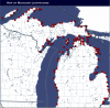
A map made by the Michigan Lighthouse Fund has information for more than 100 structures along Lake Michigan, Superior and Huron.
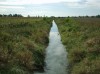
Around a quarter of Michigan’s Great Lakes tributary streams and rivers are ecologically impaired.