Echo

Fall Photo Friday: Northern Michigan reflection
|
Photo Fridays have been hijacked by the leafers! During the fall, we’ll be posting reader submitted pictures of brilliant autumn colors throughout the Great Lakes region.
Great Lakes Echo (https://greatlakesecho.org/tag/echo/page/131/)
Photo Fridays have been hijacked by the leafers! During the fall, we’ll be posting reader submitted pictures of brilliant autumn colors throughout the Great Lakes region.

Pain medicine, birth control, anti-depressants and other pharmaceuticals make their way into the Great Lakes through municipal water systems and stormwater runoff.
That threatens human health, harms wildlife and contaminates drinking water, according to a recent report.

A Great Lakes shipping canal scheduled to be dredged next spring has toxic chemicals deep below the surface, according to a recent study.
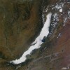
NASA recently posted a satellite image of the world’s greatest lake painted with fog. The fog’s perfect outline of Lake Baikal in Siberia is a phenomenon known as evaporation fog. It happens when surface water evaporates into cold air and forms a cloud. Lake Baikal isn’t the only great lake with fog events. The North American Great Lakes often experience lake effect, when warm, moist air blows off the lake and mixes with the cooler air over land to create fog and stratocumulus clouds.

The International Joint Commission recently highlighted the need for consistent beach monitoring throughout the Great Lakes region.

Even a region known for its water can get a little parched, as shown by the U.S. Drought Monitor late last month. Droughts in the Midwest are far less significant than those in the South, which looks like a swollen, red bee sting in this graphic from the U.S. Drought Monitor. But parts of Minnesota and Michigan’s Upper Peninsula clearly show areas of severe drought. The National Drought Mitigation Center classifies a severe drought as one that might result in crop or pasture losses, water shortages and imposed water restrictions. Drought in these areas of Minnesota and the Upper Peninsula don’t appear to be improving, according to the Seasonal Drought Outlook for the rest of the year.
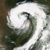
A NASA satellite caught a huge cyclone storm last week swirling over Lake Michigan and surrounding states. A cyclone is an area of low pressure where winds flow counterclockwise in the Northern Hemisphere and clockwise in the Southern Hemisphere, according to the University of Illinois cyclone webpage. They usually develop when a warm front from the south meets a cold front from the north. The cold and warm air wrap around a center of low pressure and the air in the center where they meet causes clouds and precipitation. Mid-latitude cyclones cause stormy weather in the continental U.S. While their comma shape usually identifies them, I distinctly see a shrimp in the above NASA photo. Watch the shrimp, or comma, develop in a very cool animation from the Geostationary Operational Environmental Satellites that shows the storm’s progress from September 25 to September 27.
Photo Fridays have been hijacked by the leafers! During the fall, we’ll be posting reader submitted pictures of brilliant autumn colors throughout the Great Lakes region.

The Windward Shore: A Winter on the Great Lakes (University of Michigan Press, 2011) chronicles author Jerry Dennis’s thoughts while retreating to various remote lake homes in the dead of northern Michigan winter.

In this three-part video series, scientists at the Large Lakes Observatory in Duluth, Minn., explore the implications of climate change and other human activities for Lake Superior and the African great lakes.