Air

Echo newsroom adds fleet of planes, drones and satellites
|
Seeking the high ground: Two new Echo features and another longstanding one produce a different sort of environmental journalism.
Great Lakes Echo (http://greatlakesecho.org/tag/satellites/page/2/)
Satellites provide an usual view of the Great Lakes environment.
Seeking the high ground: Two new Echo features and another longstanding one produce a different sort of environmental journalism.

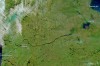
By Evan KreagerGreat Lakes EchoThe small town of Reese, just south of the crease of Michigan’s Thumb, was once a bustling supply center at the crossroads of two railways. This true-color image, taken by NASA’s Earth Observing — 1 satellite on May 21, 2012, shows the town at their intersection. The green and white square plots of land also gives insight into some of the area’s history, according to a description of the image produced by NASA. In the late 18th century, the Continental Congress decided how to govern the newly settled lands west of the Appalachian Mountains, according to the NASA description. The Ordinance of 1785 divided the land into townships, and then again into individual square mile plots, creating the colorful collage seen here.
When last week’s snowstorm and cold spell made its way through the Great Lakes, nearly 90 percent of Lake Erie froze over, according to the NASA Earth Observatory. The colorized picture above shows ice (pale blue) and snow (blue-green) formed on top of the lake. A report by Jeff Masters, director of meteorology at Wunderground.com, showed that these high levels of ice coverage had not been seen on the Great Lakes since January 1994.

This color-enhanced picture from the NASA Earth Observatory shows how the cold air moving across warmer waters of Lake Michigan and Lake Superior during this week’s arctic storm transformed water vapor into steam fog. NASA says one of its satellites on Jan. 6 captured the data used here to illustrate the difference between snow (bright orange), water clouds (white), and mixed clouds (peach). Here’s what steam fog looked like near Chicago and from the ground view.

Take a look at the NASA Earth Observatory’s remarkable photo of the gigantic snowstorm this week that affected all of the Great Lakes region, plus many other states.
New York’s Finger Lakes, as seen in true-color by a NASA satellite.

Some lakes in Minnesota are taking their time to thaw this spring, setting new “ice-out” records. Attributed to unusually cool spring temperatures, this satellite image shows lingering ice and white lake landscapes. The first photo was captured on May 12, 2013, when NASA’s Terra satellite passed over northern Minn. “Ice-out” is defined in this context as a lake being free of ice, but the definition often varies. Some define it based on ease of navigation, while others believe a lake has “iced-out” when it’s 90 percent free of ice, according to a report from the Minnesota Department of Natural Resources.
This photo was taken from the International Space Station by Canadian astronaut Chris Hadfield, commander of Expedition 35. He posted several photos on May 5 to his Twitter account showing how the springtime water flows in the Great Lakes. Lakes Huron, Erie and Ontario are featured in the photo above.
The heavy flooding that struck Michigan this month is evident in these photos from NASA’s Earth Observatory. The photos, taken from NASA’s Terra satellite, show the Saginaw River on the east side of the state and the Grand River as it flows west from the center of the state toward Lake Michigan on April 5 and April 21. A comparison of the photos shows a much-widened Grand River and major flooding conditions on the Saginaw River near the city of Saginaw, according to the NASA report. The National Weather Service continues to place Saginaw under a flood warning, stating that the river is not expected to fall below flood levels until May 1. The photos combine infrared and visual light imagery to increase the contrast between the water and land, highlighting the expansion of the rivers, according to NASA.

The Great Lakes appear through the clouds in this photo taken from the International Space Station by Canadian astronaut Chris Hadfield. He posted it recently on his Twitter account as part of a social media campaign to promote his team’s mission. Hadfield is the commander of Expedition 35, marking the first time a Canadian astronaut has been in command of the station, according to the Canadian Space Agency.