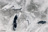
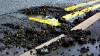
Flash Point: Laura Miller shoots Maumee River ice

We asked Great Lakes photographers to send us some of their favorite or toughest Great Lakes shots. Photographer and artist Laura Miller sent us these photos. Late January 2014 has been particularly difficult along the Maumee River in Ohio because of the amount of snow and rain we received with near-record precipitation.  These photos of an ice jam reflect the challenge of the river environment with the next challenge being flooding in the spring. Although this part of the river had an ice jam, farther upstream the water was flowing freely as the ice had been swept away.  The Maumee River is the largest Great Lakes watershed and feeds into Lake Erie.  There is a wonderful park system that follows the river providing abundant opportunities to enjoy the river.  Getting to the river isn’t the easiest during the winter months. The most difficult aspect of this photo adventure was knowing where the river bank ended and the river began.  You can’t help but respect the power and beauty of the ice when you’re actually on the banks of the river.   As you get closer to the water’s edge, you can easily go through the ice not knowing there is water flowing underneath.

Great Lakes ice cover surpasses 88 percent

Ice cover on the Great Lakes reached 88 percent this month for the first time in a decade, according to NASA’s Earth Observatory. Since 1973, average ice cover of the lakes has been just more than 50 percent. It has only exceeded 80 percent five times in the past 40 years. This image of the Great Lakes was taken by NASA’s Aqua satellite on February 19, 2014. NASA reported that NOAA’s Great Lakes Environmental Research Laboratory put ice cover at just over 80 percent.

How much snow does it take to close school?

Great Lakes school administrators are among those who hold out the longest before closing schools for snow, according to this map of how many inches trigger such an action. Any snow – in fact, any prediction of snow – triggers closings in the south, according to mapmaker Alexandr Trubetskoy, who recently posted the map to Reddit. That doesn’t necessarily mean administrators in the south are wimps. Areas without much snow also don’t have much snow removal equipment. Trubetskoy identified himself as a high school student from Vienna, Va., in a Reddit message to Great Lakes Echo.

Seven of the snowiest campuses in the nation, right here in the Great Lakes basin


Seven of the 10 snowiest college campuses across the nation are in the Great Lakes states, according to a list recently released by Accuweather. Blame that lake effect for making winters in our parts exceptionally snowy. As cold air gusts across the lakes, it meets the warm air rising off the water, creating lots of snow by the time the mixture hits the shore. Campuses in the region hold the top five and the eighth and ninth slots on Accuweather’s list. They even beat out the University of Alaska Fairbanks.

Photo Friday: Ice atop Lake Erie

When last week’s snowstorm and cold spell made its way through the Great Lakes, nearly 90 percent of Lake Erie froze over, according to the NASA Earth Observatory. The colorized picture above shows ice (pale blue) and snow (blue-green) formed on top of the lake. A report by Jeff Masters, director of meteorology at Wunderground.com, showed that these high levels of ice coverage had not been seen on the Great Lakes since January 1994.

Ice forming along Chicago River

The Chicago River just west of where it enters Lake Michigan with what is known as  brash ice, floating fragments of ice usually less than two meters across. Image: Greg Monahan