Great Lakes ice cover surpasses 88 percent

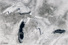
Ice cover on the Great Lakes reached 88 percent this month for the first time in a decade, according to NASA’s Earth Observatory. Since 1973, average ice cover of the lakes has been just more than 50 percent. It has only exceeded 80 percent five times in the past 40 years. This image of the Great Lakes was taken by NASA’s Aqua satellite on February 19, 2014. NASA reported that NOAA’s Great Lakes Environmental Research Laboratory put ice cover at just over 80 percent.

Invasive Species: Sea Lamprey

By Evan KreagerGreat Lakes Echo

The Nature Conservancy has named sea lampreys one of the five “usual suspects” invading the Great Lakes basin. These eel-looking parasites find a host and suck the life out of it. During the length of one life cycle, a sea lamprey can kill up to 40 pounds worth of fish and can grow up to 3 feet long. Sea lampreys are native to the Atlantic Ocean, Lake Ontario and the St. Lawrence River.

Seven of the snowiest campuses in the nation, right here in the Great Lakes basin


Seven of the 10 snowiest college campuses across the nation are in the Great Lakes states, according to a list recently released by Accuweather. Blame that lake effect for making winters in our parts exceptionally snowy. As cold air gusts across the lakes, it meets the warm air rising off the water, creating lots of snow by the time the mixture hits the shore. Campuses in the region hold the top five and the eighth and ninth slots on Accuweather’s list. They even beat out the University of Alaska Fairbanks.

Photo Friday: Land distribution around railroad supply town

By Evan KreagerGreat Lakes EchoThe small town of Reese, just south of the crease of Michigan’s Thumb, was once a bustling supply center at the crossroads of two railways. This true-color image, taken by NASA’s Earth Observing — 1 satellite on May 21, 2012, shows the town at their intersection. The green and white square plots of land also gives insight into some of the area’s history, according to a description of the image produced by NASA. In the late 18th century, the Continental Congress decided how to govern the newly settled lands west of the Appalachian Mountains, according to the NASA description. The Ordinance of 1785 divided the land into townships, and then again into individual square mile plots, creating the colorful collage seen here.

Yellow jugs keep drugs from Great Lakes

Reports continue to show increasing traces of pharmaceuticals in the Great Lakes. Until recently, it has been commonplace to simply throw away or flush unused and unwanted drugs. The Yellow Jugs Old Drugs program offers a solution to this issue.