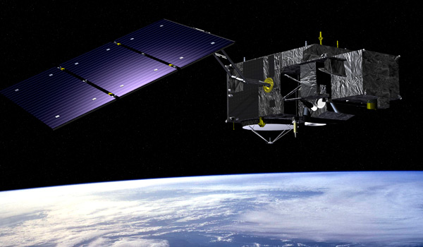
An image of Sentinel-3, a European Space Agency (ESA) ocean and land mission composed of three satellites (Sentinel-3A, Sentinel-3B and Sentinel-3C). It’s one of several used by the Cyanobacteria Assessment Network (CyAN) to detect harmful algal blooms. Image: ESA
By Claire Moore
Cyanobacteria can’t grow in the Great Lakes Basin without NASA knowing.
Green or reddish-brown streaks popping up in the region’s freshwater can be a problem. The streaks are cyanobacteria, little aquatic organisms that grow and thrive in warmer water. In favorable conditions, they can produce toxins that make humans and animals ill.
But satellites high above Earth keep an eye on their growth.
The space agency uses a network of satellite technology to monitor when and where toxic patches of cyanobacteria form. Bursts of growth — known as harmful algal blooms, or HABs — are captured by satellites of the Cyanobacteria Assessment Network, or CyAN.
Consider it a group project by several federal agencies: the National Oceanic and Atmospheric Administration, Environmental Protection Agency and U.S. Geological Survey all have a hand in CyAN. Since 2015, the network has kept a watchful eye on not only oceans, but on the Great Lakes Basin.
“We’re in the fifth year of the project,” said Bridget Seegers, a research scientist at NASA’s Ocean Ecology Laboratory. “It was established to try to standardize the use of satellites to look at cyanobacteria blooms.”
The EPA took the lead to get the project going. Other agencies were brought in for their expertise: NOAA has a history of studying cyanobacteria on the Great Lakes, USGS catalogues inland water temperatures and NASA has satellites in orbit.
“All the groups got together to make the science project happen,” Seegers said.
That science project came in handy in July 2019, when a large, dense harmful algal bloom appeared over the surface of Lake Erie. Images of that algal bloom were captured by NASA’s Operational Land Imager, which is on the Landsat 8 satellite.
The blooms were expected: NOAA researchers had forecasted that algal growth would spike in 2019, especially over Lake Erie.
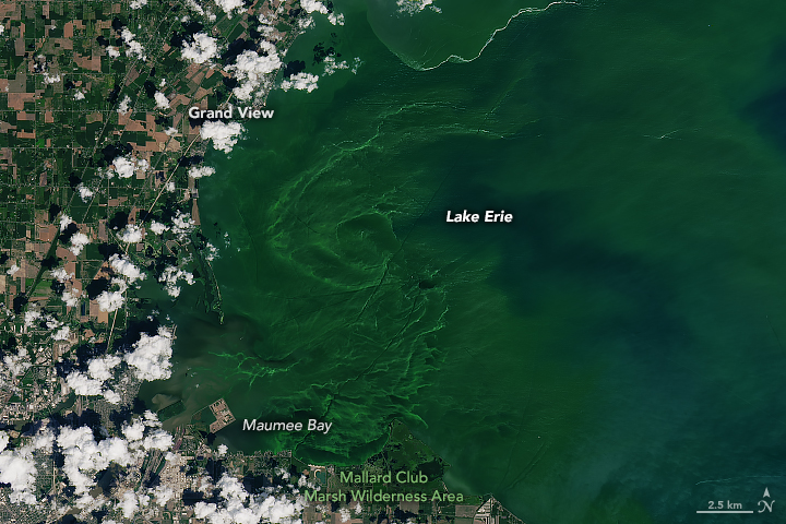
A harmful algal bloom on July 30, 2019. This image was captured by the Operational Land Imager on the Landsat 8 satellite. Image: NASA’s Landsat 8 satellite
A variety of satellites monitor Earth, so CyAN officials sometimes rely on ones that aren’t NASA’s. Sentinel-3 satellites are crucial to CyAN, and they belong to the European Space Agency. Sentinel-3 is fitted with an Ocean and Land Colour Instrument, or OLCI. It has a 300-meter pixel size for taking images.
“We specifically talk a lot about the pixel size,” Seegers said. “The smaller the pixel size, the more you can get within a lake, so the higher the resolution.”
Other satellites are smaller, with 10- or 30-meter pixel sizes. Those are excellent for taking clear shots of smaller lakes, but it takes them 16 days to cover the whole planet, Seegers said.
“With the 300-meter, we get coverage every two to three days,” she said
Wavelength capabilities of satellites are also important, especially to pick out colors of HABs. ESA Sentinel-2 satellites are used to take color-rich images. Landsat satellites have 30- to 50-meter pixel sizes, depending on what wavelength is needed
But taking photographs of these inland waters isn’t always easy for CyAN.
“The atmosphere over the ocean, in some ways, is a little easier to predict than the atmosphere over Lake Erie, where you have wind blowing and dust from farm fields and cities,” Seegers said.
Here’s another catch – what happens if it’s a cloudy day?
“When it’s cloudy, [satellites] can’t get a good image,” said Steve Ruberg, a supervisor to the technology branch of NOAA’s Great Lakes Environment Research Laboratory.
In those instances, NOAA relies on low-flying aircraft to take images and gather lake data.
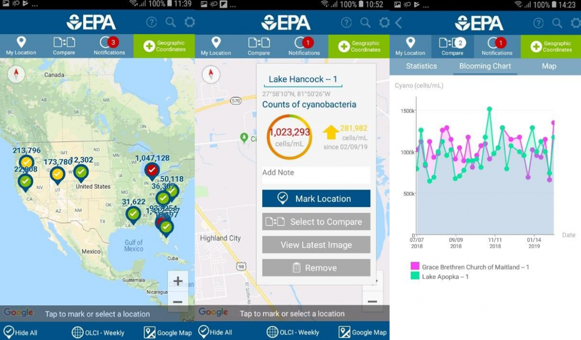
A demo of the EPA’s CyAN mobile application. Location coordinates can be input to find region-specific satellite data. Image credit: CyAN mobile app
“One of the systems we use is an airborne hyperspectral system — which is basically taking a sensor that might go on a satellite — putting it in an aircraft, flying it around and mapping areas,” Ruberg said.
Once installed and in the air, the system automatically collects water quality data.
“We have it programmed to only turn on when the GPS in the system is within a certain bounded area,” Ruberg said. “They bring it back, and we download the data and analyze it to see where we have harmful algal blooms, or HABS.”
The imaging system includes a camera with a high spectral resolution, which means it’s excellent at detecting colors.
“The color bands you can see are much higher than pretty much any satellite that’s up there right now, and far better than the human eye,” Ruberg said.
NOAA’s hyperspectral imaging system isn’t part of CyAN, but it is a precursor to satellites with higher resolutions. One higher-resolution NASA satellite — Plankton, Aerosal, Cloud, ocean Ecosystem or PACE — is set to be launched in 2022.
What’s to be done with all these satellite and aerial images, once they’re captured?
A CyAN app allows users to access a trove of the network’s collected algal bloom satellite data. EPA scientists created it to let local and state water quality managers see if and where HABs are occurring in their areas. It’s available for download on Android devices. An app for iPhones is also in the works.
You can subscribe to weekly bulletins on harmful algal blooms by visiting NOAA’s Great Lakes Environment Research Laboratory website.
Landsat 8 and the under development Landsat 9 were and are joint with NASA but once L8 finished on-orbit checkout, it is wholly owned and operated by USGS. The same will be for Landsat 9.
NASA does a lot of science work with the data but we at USGS fly the satellite, bring the data down, process it, distribute it, and archive it.
https://www.usgs.gov/land-resources/nli/landsat
https://www.usgs.gov/centers/eros
https://www.usgs.gov/land-resources/nli/landsat/landsat-8?qt-science_support_page_related_con=0#qt-science_support_page_related_con
After the Landsat 8 satellite was constructed and launched into orbit by NASA, USGS took over in primary management of it. But it’s jointly managed by NASA, especially Goddard Space Flight Center, and USGS: https://landsat.gsfc.nasa.gov/landsat-data-continuity-mission/
We don’t think it inaccurate to refer to “NASA’s Landsat 8 satellite” if NASA built, launched and still uses it. But to reduce any possibility of confusion the story now refers to “Landsat 8.”
Landsat 8 (and 7) are owned and operated by the US Geological Survey (part of the Dept of Interior) not by NASA. Please corrrect.