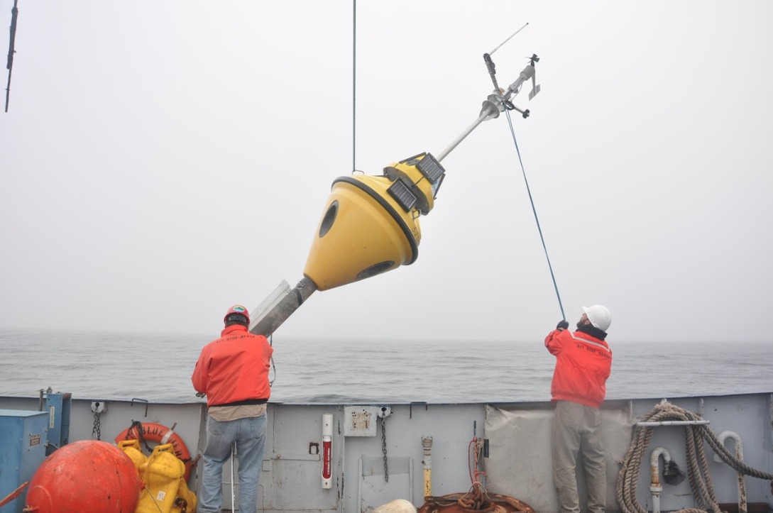
Researchers deploy a meteorological buoy on Lake Superior. Image: Daniel Titze
By Colleen Otte
Researchers studying ocean ice plow through it in an icebreaker.
Researchers studying small inland lake ice walk out onto it.
Researchers studying Great Lakes ice are caught in limbo.
“The Great Lakes sit in this sort of gap in between those two, and because of this, logistically they are much more difficult to study,” said Jay Austin, professor of physics and astronomy at University of Minnesota Duluth’s Large Lakes Observatory. “There isn’t an in-between solution for studying the ice on the Great Lakes, so most of what we know is from satellite data.”
Austin coauthored a study that sought to solve the dilemma and that was published recently in the Journal of Great Lakes Research.
The work could lead to better predictions of ice conditions needed by shippers. And it prompted such questions as what does the sound of Great Lakes ice mean?
“The motivation behind this work is that ice on the Great Lakes is a very significant feature of the lakes, but one that we know very little about just because it’s so hard to go out there and take measurements of it,” said Daniel Titze, a physical limnological researcher and the study’s lead author.
Most of the ice databases developed by the National Oceanic and Atmospheric Administration’s Great Lakes Environmental Research Laboratory rely on satellite data with some observation-based verification, said Andrew Gronewold, a hydrologist and physical scientist for the lab.
Because the observations are sparse, the data primarily comes from translating satellite images into pixels and then identifying how much of each pixel contains ice, he said.
But the University of Minnesota Duluth researchers took their eye from the sky and instead peered beneath the ice.

Researchers recover a mooring with their research boat, the Blue Heron. Image: Daniel Titze
“This was an opportunity to study some properties of ice by making direct observations–by having equipment in the water underneath the ice,” Austin said. The equipment can be left out over the winter.
It includes acoustic Doppler current profilers, which Titze said are intended to measure water current, but in this case measured ice movement. They float near the surface and are anchored to the bottom of the lake.
“That spanned the water column,” Titze said. “In the case of the location that we got most of this data from it was in about 600 feet of water–175 meters.”
Measurements from these instruments indicate that Lake Superior ice more resembles the ice on oceans than ice on small lakes, Austin said.
“It’s really by-and-large free-drifting, even during that really cold, icy year that we were looking at,” Titze said. “It all comes from that 2013-2014 winter which was record-high ice cover, record-cold air temperature–it was the polar vortex year that everybody was talking about.”
In addition to ice drift, the researchers also measured what is called keel size and abundance–the number and depth of ice ridges that pile up as ice sheets stack upon each other.
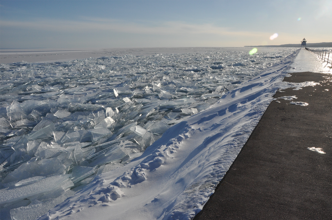
Ice debris accumulated in Two Harbors, Minnesota, during the 2013-2014 winter. Image: Daniel Titze
The sensors were deployed between 10- and 20 feet below the surface so any ice ridge deeper than that would hit the mooring and pull them deeper, Titze said. A pressure sensor documented just how deep it was pulled down.
The ice keels were nearly 40 feet deep, based on calculations of how fast the ice was moving before and after it passed, and a couple football fields wide, Titze said.
“It wasn’t just one or two of these,” he said. “Based on how often we saw them, we think that they comprise a significant fraction of the total volume of ice on the lake.”
While some researchers have gone out with the Coast Guard to drill down into and observe these massive ice keels in the past, this study is the first time anybody has documented the keels from a specific location throughout an entire winter, Titze said.
It’s difficult to model annual ice coverage until further observations are gathered, he said. With predictions of the location and thickness of the ice, researchers can improve models to allow industries like shipping to set more appropriate start and end dates for their season.
Fairly accurate weather forecasts are available five days ahead of time because of computer models, Austin said. But we don’t have that capability for ice.
“A lot of these observations we made in this particular experiment were observations of opportunity, where something gave us information that it wasn’t initially designed to do,” he said. For example, “we realized there is a really interesting acoustic environment under the ice–in other words, the ice makes sound, and we’re trying to figure out what we can learn from that sound right now.”

The Apostle Islands ice caves that formed during the cold 2013-2014 winter. Image: Daniel Titze
The researchers found that Lake Superior and Lake Erie form more ice than other Great Lakes. Lake Superior is farther north and colder. Lake Erie is very shallow and quickly cools, Austin said.
The researchers have also begun analyzing how sensitive the Great Lakes are to climate, Titze said.
“They’re very sensitive to small changes in air temperature,” he said. “So when people say the world is going to warm by a degree or two and it doesn’t sound like much, these are examples of systems where that would make a huge difference in the overall dynamics.”

The ice caves are only accessible during the coldest, iciest winters–when the lake freezes and you can safely walk out to them. Image: Daniel Titze
Ice modifies shorelines and shore habitats, Austin said. Some organisms thrive under it.
“There are certainly some attributes of the ecosystem that are directly impacted by ice cover,” Gronewold said.
But the onset, thickness and offset–or retreat–of the ice may impact commercial navigation even more directly, he said.
“The commercial shipping industry and other vessels will try to navigate through the waters as long as they safely can,” Gronewold said.
If you want a quick study on Lake Erie ice, Google ” Joe Barrett ice boom “; the lack of movement of the ice cover by the ice boom, has caused at least four gigantic problems in the lower Great Lakes.