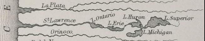
This detail from an 1860 world map shows the St. Lawrence River flowing to the west and reverse images of the Great Lakes.
By David Poulson
An 1860 world map reverses the flow of the St. Lawrence River and the shapes of the Great Lakes.
It’s no cartographer’s mistake, as map collector Peter Roehrich explains in this post about a detail of one of the maps in his collection. In fact, it uses the technology of the time to better explain the world.
Page space is a valuable commodity of a paper map, Roehrich says. In this case, the space unused by the main map holds rivers depicted as “comparatives.”
Rivers in the western hemisphere are shown draining to the left – or west. Those in the eastern half flow eastward to the right. Of course neither is necessarily true. What’s more, the geographic order of the Great Lakes is reversed from reality.
But they are accurate in terms of their order relative to the river mouth. And Roehrich notes that the lakes’ shapes are flipped, indicating that this was no mere accident. Flipping the orientation of the lakes while flipping the river’s flow would help viewers locate centers of Midwest commerce, he said.
“The quirky illustration of the Great Lakes underscores the ingenuity of 19th century cartographers, skill of engravers, and their efforts to make comparative views valuable and useful to their readers,” he writes.
Check out Roehrich’s blog for more.