An image from a NASA earth observation satellite traces the twisted trail of debris left by the 200 mph tornado that recently scraped across northern Illinois.
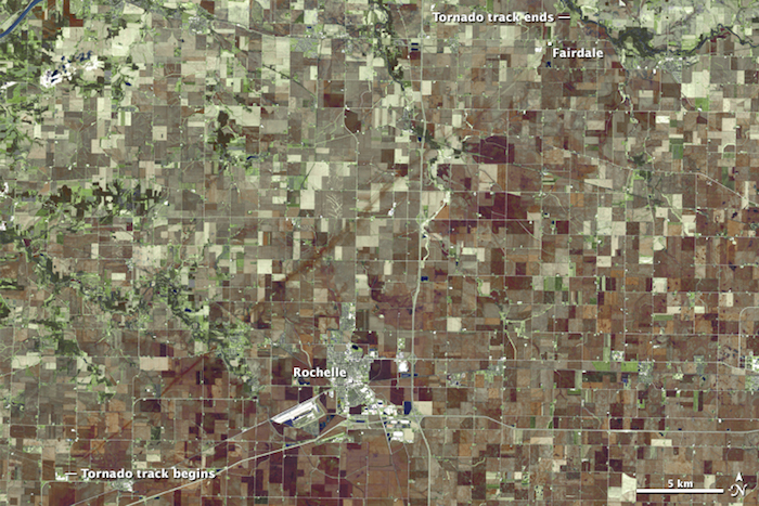
Radar and aerial surveys of the tornadoes’ path help meteorologists explain what happened. Image: NASA Earth Observatory, Joshua Stevens
Like many snapshots from space, the image was manipulated to highlight the most important feature — the trail left by the tornado.
Individual houses are too small to distinguish, but NASA’s Earth Observatory points out living vegetation (in green), newly planted fields (in brown) and whole towns (in patches of grey).
From above, the destruction follows a nearly straight line across the largely agricultural landscape.
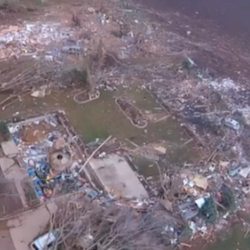
Click image to watch drone footage of the debris. Video: NBC Chicago, courtesy of Daniel Isaacson
From below, the landscape’s not so ordered.
Drone footage reveals the extent of the damage in north-central Illinois.
From mangled trees to leveled homes, the tornado reached an EF-4 classification, one level below the most severe classification using the Enhanced Fujita Scale.
And despite nearly missing the Fairdale, Ill. community, reports confirmed the death of two women, and left nearly 70 structures demolished.
EF-4 and EF-5 tornadoes (the most intense) are uncommon to northern Illinois, but do occur on occasion.
Read more or view a map of tornado tracks in the lower Great Lakes between 1950 and 2014 at NASA’s Earth Observatory.
BONUS: See real-time, on-the-ground footage of the twister in Fairdale, Ill. in this video.