Review
The standing silhouette of Detroit is ripe for social and political commentary, nonfiction and art.
June Manning Thomas and Henco Bekkering map land and community issues in Detroit, including the impact of the environment on development.
Their book, Mapping Detroit: Land, Community, and Shaping a City, uses graphics, primarily maps, to organize and warily interpret the many land-related matters of Detroit’s vacancy, redevelopment, industrial change and transportation.
More of an intelligible atlas than a book, though no less thought provoking, Mapping Detroit describes a city that continues to have national implications.
It’s a thorough reference that uses the expertise of its 13 co-authors, including a map archivist, historian, architect, urban planner and designer.
Editors Manning Thomas and Bekkering open the book with a dismal portrait of the city — a time capsule — describing it as “swaths of vacant and decaying residential properties, neglected and shuttered parks and community facilities, abandoned or marginalized retail stores, and empty factory buildings.”
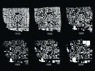
Mapping Detroit’s fragmented downtown. Image: Mapping Detroit, courtesy of DTE Energy, Detroit Edison Co., Plunz and Kelbaugh
This familiar picture is just as devastating to read as it is to see.
Mapping Detroit is in three parts.
Part one delivers the context for the city’s expansion prompted by demands of agriculture, military and trade.
Part two discusses contemporary issues, including fragmented neighborhoods and the social give-and-take of economic recovery.
The final part recommends fixes and reports on opportunities for environmental intervention and community engagement.
The book highlights Detroit’s story through graphics and makes statistically relevant recommendations that conclude with a social and environmental proposition to drastically reimagine the city.
Once the pieces of Detroit’s dilemma are connected, it makes sense that Manning Thomas and Bekkering recommend that environmental revitalization be addressed first.
After all, aesthetic beauty attracts the creative class who are already responsible for much revival in the city.
At this intersection of urban renewal and environmental recovery, these communities begin to fill the gaps created by the racially divided, residential patchwork.
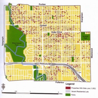
Homeowners who use adjacent lots, creating “blots.” Image: Mapping Detroit, courtesy of Detroit Planning and Development; Michigan Department of Information Technology; Southeast Michigan Council of Governments; and GoogleMaps
In fact, blots, or units the authors describe as being between a block and a lot in size, are already restoring much of the natural landscape.
But authors’ say Detroit’s underground also holds potential for sustainable relationships for environmental, economic and cultural improvement.
Restoring or “Daylighting” Detroit’s streams to a natural state is one recommendation that would uncover water buried by much of the city’s sewer system.
This would not only improve city aesthetics, but uncovered streams, strips of green space and wetlands could also connect Detroit’s vacant lots.
Of course, these are not new ideas.
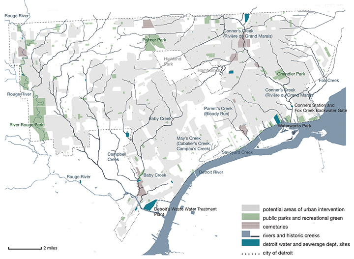
Revisiting the potential for stream recovery, a map of historic and existing rivers and streams. Image: Mapping Detroit, courtesy of Detroit Water and Sewage, CDM and the Urban Streams Restoration
The book acts as a repository for redevelopment; “It puts together ideas or initiatives that already exist, to knit a whole,” said Lars Gräbner, Detroit architect and coauthor.
“When paired with current initiatives, the book could be used as a proposal for land use,” he said.
But the strength of this book lies within the city’s rich culture captured in images, maps and diagrams tracing the city’s development.
The book’s breadth is overwhelming but so is the dilemma of Detroit.
Whether a problem social, political or environmental, the significant challenge of size remains.
As Manning Thomas and Bekkering put it, Detroit is a “physical envelop in many ways too big for its remaining contents.”
Published March 2015, Mapping Detroit: Land, Community, and Shaping a City is available for purchase ($34.99) as paperback or e-book through Wayne State University Press.
Kevin Duffy is a reporter for Great Lakes Echo.