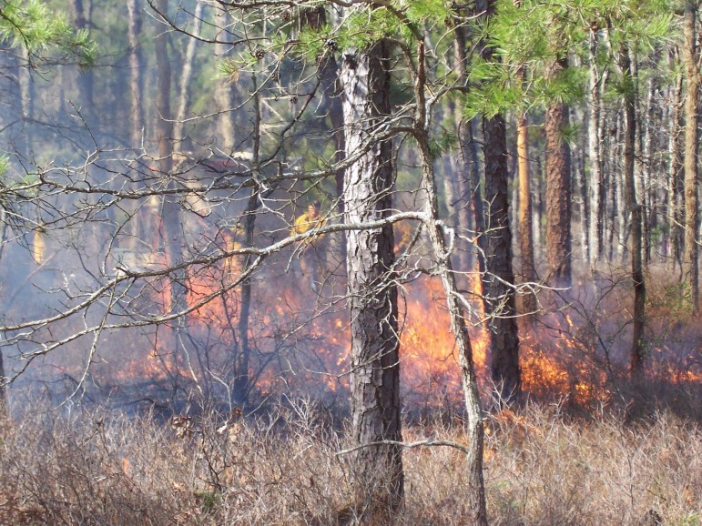
Flames produced during a prescribed fire at the New Jersey Pine Barrens in March, 2010. Image: Michael Kiefer
A team of researchers has developed a system that predicts smoke direction from low-intensity forest fires.
Researchers at the U.S Forest Service and Michigan State University developed the system to help fire managers control prescribed fires. These fires are used to manage vegetation and fuel, said Warren Heilman, a research meteorologist for the U.S. Forest Service.
“If there is a lot of flammable vegetation on the ground, the surface can catch on fire from lightning,” Heilman said. “This increases the chance of a wildfire. Prescribed fires help to burn off these surface fuels.”
The system is a computer program called ARPS-CANOPY, which stands for Advanced Regional Prediction System.
Much like a weather-forecasting model, it calculates changes in air temperature, soil temperature and wind speed to help fire managers determine where the smoke is headed, said Michael Kiefer, a geography research assistant at Michigan State University.
“The computer model solves equations and gives us information about how the atmospheric conditions near the fire may change over a matter of minutes to days,” Kiefer said.
The system has not been tested in the Great Lakes region yet. U.S. Forest Service scientists have tested it twice in the Pine Barrens of New Jersey to help manage water, soil, air and wildlife in nearby forests.
“The New Jersey Pine Barrens were chosen because there is a U.S. Forest Service, Northern Research Station facility there and that facility has collaborated with the New Jersey Forest Fire Service in the past,” said Kiefer.
The research team hopes the system will be available to all fire managers in the near future. Kiefer said environmental agencies and private land owners like the Nature Conservancy are the intended users.
Heilman said once awareness is raised, fire managers can access the system online and enter “basic information about where fire will occur, the time of day, and vegetation status. Then, researchers could give them [fire managers] a prediction.”
Kiefer said local firefighters may use data once the trial phase is complete and the system becomes well known to the fire management community.
“It is conceivable that the high-resolution weather data produced by ARPS-CANOPY could be used to develop future firefighting applications,” said Kiefer.
Heilman said there are already modeling systems that predict where smoke will go from wildfires, but not for prescribed fires. While smoke from prescribed fires may not impact air quality, they do pose a threat to nearby communities.
“The smoke can hinder visibility on roadways and air traffic. It can also threaten health if smoke is inhaled,” said Heilman. “The system will tell fire managers where the smoke will go three days in advance, and if it threatens a community, the manager will pick a different day.”
Craig Fitzner, air monitoring unit supervisor for the Michigan Department of Environmental Quality (DEQ) said wildfires harm air quality in Michigan, but that prescribed fires are not a problem.
“We have found that the smaller scale of prescribed fires is not enough to adversely impact regional air quality,” Fitzner said.
The Department of Natural Resources (DNR) in Lansing has similar models that predict the direction of smoke. A system called Bluesky provides the most accurate data, said DNR fire management specialist Donald Johnson.
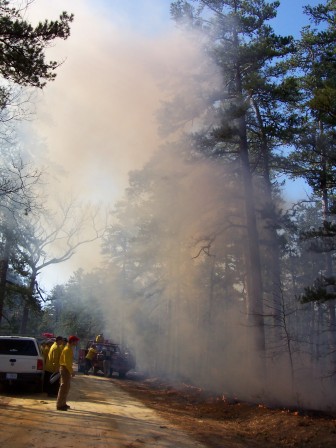
Smoke rises from a prescribed fire at the New Jersey Pine Barrens in March, 2010. Image: Michael Kiefer
“Bluesky is the most complete, but complicated model. When we are in populated areas, it allows us to figure out under what parameters we can conduct the burns so that we don’t harm anyone’s health,” he said.
Prescribed fires are performed periodically to manage invasive weeds. One example it phragmites that usually grow in marshlands and are tough to kill.
“We first kill the weed with herbicide,” sometimes two to three applications. “Then, we follow-up with prescribed fire after that,” said Johnson.
Phragmites produce a lot of ash and there’s a need for a system that can predict its direction, Johnson said
“The models we currently use do everything except when burning phragmites,” he said. “This produces a lot of ash and gets carried in the air. We don’t have a model that will predict the movement of ash. It’s heavy compared to gases and falls out of the smoke column close to the source.”