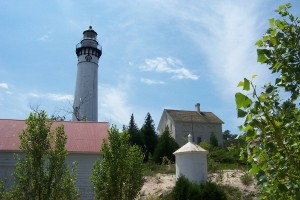
South Manitou Lighthouse overlooks Lake Michigan on the coast of South Manitou Island. National Park Service photo by Kerry Kelly.
The National Park Service and MichiganTrailMaps.com have produced new trail maps of a pair of Lake Michigan islands near Traverse City, Mich.
North Manitou Island and South Manitou Island, part of Sleeping Bear Dunes National Lakeshore, have been added to MichiganTrailMaps.com’s Classic Trails of Michigan map series. Each map illustrates trail grades, primitive roads, maintained trails and unmarked modern and historic pathways. They also mark historic sites, ruins, natural features, elevation changes and hiking amenities found throughout the islands.
Each map costs $4.95, and are available at the Sleeping Bear Dunes Visitor Centers, MichiganTrailMaps.com, the Manitou Island Transit ferry company and outdoor shops throughout the state.
South Manitou Island boasts some of the highest dunes in Michigan and a stand of old-growth white cedar along its 17 miles of trails, according to Jim Dufresne, founder of MichiganTrailMaps.com. Its larger neighbor, North Manitou Island, features 30 miles of trails through maple and beech forests, past historic ruins and along bluffs. The islands together receive about 11,000 annual visitors.
The news maps, printed on cardstock and coated with water-resistant material, are meant to endure the rugged conditions hikers on the islands will face.
Bob is correct. The ancient trees are White Cedars, not White Pines. The height of the cedars do not rival the height of the majestic White Pine trees at Hartwick Pines State Park (or at Estivant Pines in the U.P.), but I found their girth to be most impressive. Reportedly, the relatively small patch of cedars escaped the lumberman’s axe since the swampy site was more difficult to access at the time. Thank goodness for wetlands.
Although I have never been to South Manitou I believe the statement making reference to old growth pine may be incorrect. Not to be too critical, but my understanding is that there is an old growth stand of white cedar, not white pine. I mention this because I’ve been wanting to see these old white cedars for several years.
I bought one as a gift (N. Manitou). It is high quality and quite accurate. Plus you are supporting local given that Jim Dufresne is from the metro-Detroit area.