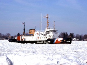
A Coast Guard Cutter makes its way through the 1984 St. Clair River ice Jam. Photo by Per Verdonk.
By Sarah Coefield, coefield@msu.edu
Great Lakes Echo
June 4, 2009
An ice jam that stalled the St. Clair River for nearly a month in 1984 may have caused Lake Huron to drain faster in subsequent years.
Lake Huron water levels have been dropping the past 40 to 50 years. That prompted a Canadian group of Georgian Bay cottage associations, upset that the low water threatened wetlands and diminished waterfronts, to search out the cause. Consultants for the Georgian Bay Association in 2004 identified the U.S. Army Corps of Engineers’ dredging of the St. Clair River as the offender. Baird and Associates cited on-going sediment erosion for the increased flow of water through the river which drains Lake Huron into Lake St. Clair.
Not so, says a draft report issued by the International Joint Commission in May.
The IJC, which is a U.S. and Canadian group that helps the governments resolve boundary water issues, launched a multimillion dollar study in 2007 to identify potential natural causes behind the water drop. The results are in, and one potential culprit is the massive ice jam of 1984, said Syed Moin, the Canadian co-manager for the project.
Citing a series of clues, including modeling projections, riverbed measurements and historical data, Moin said that erosion caused by the ice jam could account for nearly four inches of Lake Huron’s lowered water levels.
Researchers knew from riverbed measurements that sections of the river deepened between 1971 and 2007. But they had no way of knowing when the change took place. Then ice jam modeling results came in, and “1984 was looking good,” Moin said.
Ice jams can erode river bottoms
The largest ice jam in the river’s historical record formed on April 5, 1984. It lasted 24 days, clogging about 20 miles of river with thick ice and leaving cargo ships stranded at either end.
Jams are common in areas with cold winters, and form when ice floating on the surface block off the width of a river.
Hung Tao Shen, an engineering professor at Clarkson University in Potsdam, N.Y, studies ice in natural systems. He said jams like the one that formed on the St. Clair form when ice breaks apart, either naturally or because ships break it up, and floats down the river.
“Where we have a lot of broken ice pieces coming from upstream, coming down to … where the river flow cannot carry the ice forward, they would start a jamming,” Shen said.
According to a 1986 report by Jan Derecki and Frank Quinn in the Journal of Hydraulic Engineering, the ice for the 1984 ice jam originated in Lake Huron, and was broken up by ships and pushed downstream by northerly winds.
Once the jam forms, surface ice develops upstream, Shen said. Ice can also accumulate under the surface of the jam. As the river’s waterway fills with ice, the water is forced through a smaller area, making it move even faster. The water’s increased velocity can scour the river bottom and transport eroded sediment downstream, Shen said.
Whether the increased flow leads to erosion depends on the river bottom’s composition.
“It doesn’t just depend on the ice,” Shen said. Large rocks and gravel are less erodible than fine sediment.
And just what the St. Clair River’s bottom was composed of in 1984 is the “million dollar question” Moin said.
Underwater videography conducted for the IJC study identified cobbles and large gravel in the upper reaches of the St. Clair River, but the study did not focus extensively on the lower reach where the ice jam blocked the river. “Whatever was there, it was the type of material that could be moved under high flow conditions,” Moin said.
Despite the uncertainty over the ice jam’s ability to erode the river, scientists are certain something significant happened in 1984.
Modeling shows changes in the river
Steven Daly, an engineer with the Army Corps of Engineers Cold Region Research and Engineering Laboratory, modeled how ice could affect how water moves through the St. Clair River.
Ice data was rarely recorded for the St. Clair River, Daly said, but when his model was compared to a year with ice data, it accurately predicted the presence of ice.
“It appeared that something changed … in 1984,” Daly said. The river’s increased flow and water carrying capacity, as estimated from water levels and his model, has been consistent since that change, he said. “The model shows there should be a big ice impact in 1984.”
Studies expected to be completed by the end of June examine the 1984 ice jam in more depth and will determine if conditions would have led to the erosion predicted by the model, Moin said. “(Researchers) will be looking at environmental conditions at the time of the jam,” he said. They will pay particular attention to the weather and the possibility of the ice growing downward and further constricting the water’s flow, he said.
The IJC’s underwater videos show evidence of cobbles and gravel in the upper reaches of the St. Clair River.
When you take the plug out of the bottom of a liqued container it lowers the top level. Do you suppuse the cannel at the bottom of lake Michican is lowering it and the oher lakes?
Pingback: Ice, ice baby | Great Lakes Echo
Pingback: Great Lakes Echo» Blog Archive » On the (Lake) Level
Pingback: Great Lakes Echo» Blog Archive » On the (Lake) Level